Urban Integration, Spatial Reconfiguration, and High-Density Adaptation
Examining how naturist systems evolve within urban environments through spatial precision, adaptive zoning models, and integration into high-density planning frameworks.
The future scalability of naturist systems depends on their ability to reconfigure spatial and operational models for urban integration, using micro-zoning, visibility management, and adaptive use strategies to maintain stability and interpretability within high-density environments.
3.1 The Urban Constraint as a Primary Evolution Driver
Urbanisation is a dominant external driver shaping the future of naturist systems.
Urban environments are characterised by high population density, limited availability of secluded spaces, competing uses of public land, and increased regulatory oversight.
These conditions impose a structural constraint: naturist systems can no longer rely primarily on remote or low-density environments.
Future viability depends on adaptation to high-density spatial contexts where visibility is increased, interaction with non-participants is more likely, and tolerance thresholds are more sensitive.
Urbanisation therefore requires a transition toward precision-based system design.
3.2 Reframing Naturist Spaces Within Urban Planning
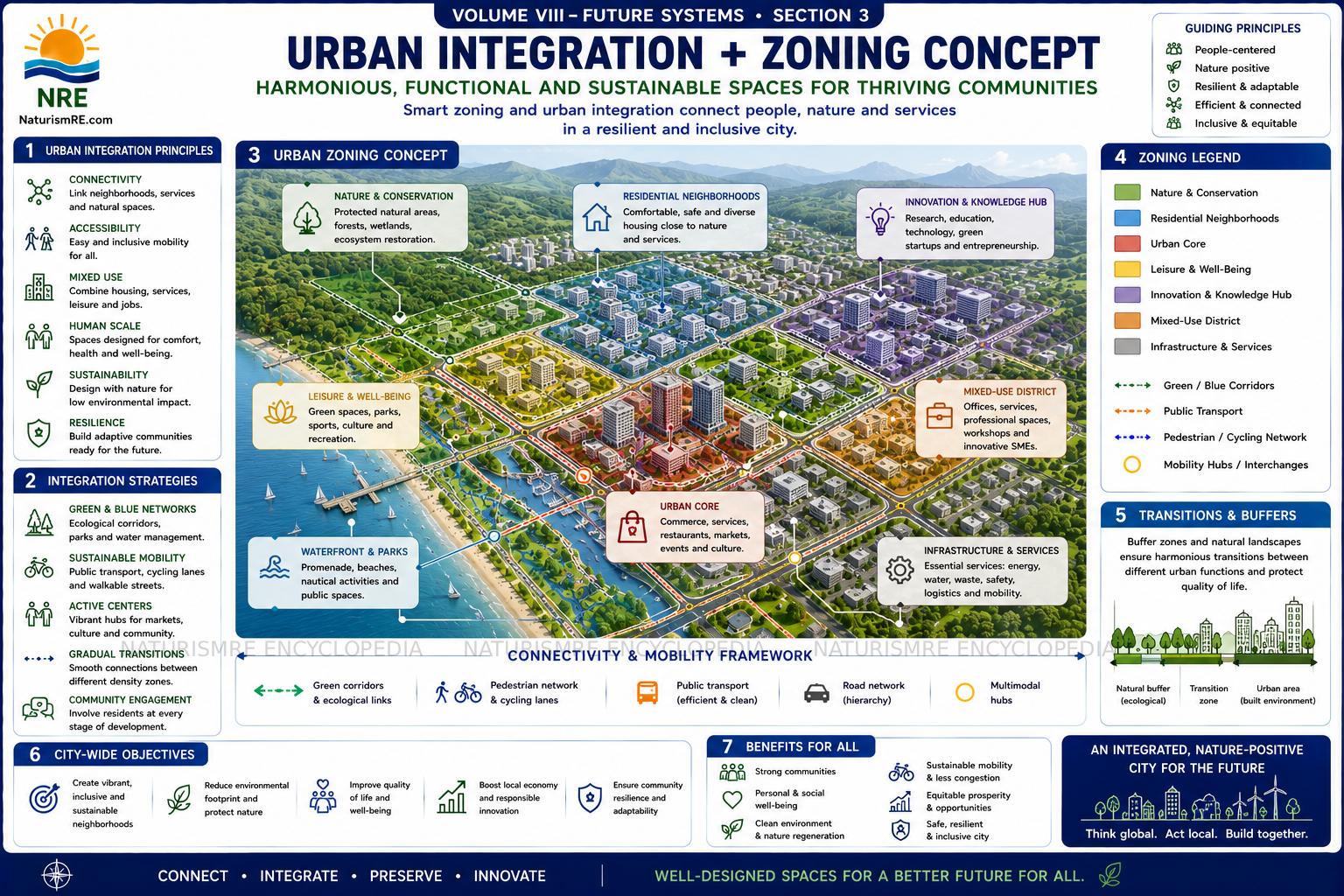
In urban contexts, naturist environments must be reframed as designated functional zones within broader planning systems rather than as isolated or exceptional spaces.
This aligns naturist environments with established urban categories such as recreational zones, wellness-oriented spaces, and specialised use areas.
Integration within urban planning requires compatibility with zoning frameworks, alignment with public space management strategies, and consideration of accessibility and coexistence.
Naturist systems must therefore be designed for inclusion within planning logic rather than positioned outside it.
3.3 Spatial Reconfiguration and Micro-Zoning Models
Urban environments require spatial reconfiguration, shifting from large, isolated areas to micro-zoning models.
These are characterised by smaller, precisely defined spaces with clear boundaries, controlled access points, and integration within larger multi-use environments.
Micro-zoning reduces visibility exposure, improves control over interaction with non-participants, and facilitates alignment with regulatory conditions.
Such environments function as contained interaction zones rather than open, undefined spaces.
3.4 Managing Visibility in High-Density Contexts
Visibility is a critical variable in urban deployment.
Line-of-Sight Management
Spatial positioning and environmental design reduce unintended visibility from unrelated public areas.
Proximity Control
Separation from high-traffic pathways limits unnecessary interaction with non-participants.
Natural and Structural Screening
Terrain, vegetation, or built elements support contextual appropriateness without requiring concealment.
Entry and Viewing Angle Control
Controlled spatial orientation reduces interpretative ambiguity and supports predictable interaction.
The objective is not concealment, but contextual appropriateness, ensuring that exposure aligns with environmental expectations and unintended observation is minimised.
3.5 Temporal Zoning and Dynamic Use Models
Urban constraints may also require temporal adaptation.
Environments may operate during specific periods aligned with lower-density usage patterns, enabling shared use of space without permanent designation.
Temporal zoning reduces conflict with other users and allows controlled testing of system viability.
This introduces dynamic use models that increase flexibility and responsiveness within urban contexts.
3.6 Interaction Management in Mixed-Use Environments
Urban spaces are inherently multi-use, requiring management of interaction between participants and non-participants.
This includes maintaining clear spatial boundaries, ensuring predictable participant behaviour, and managing movement flows.
Failure to manage interaction may result in increased complaints, negative perception, and regulatory intervention.
Effective systems ensure that participation remains contained within defined parameters and that coexistence is maintained without disruption.
3.7 Infrastructure Considerations and Minimalist Design
Urban deployment may require supporting infrastructure such as access pathways, basic amenities, and environmental management features.
Infrastructure must remain proportionate, aligned with environmental purpose, and compatible with surrounding land use.
Minimalist design is often preferable as it reduces visual impact, lowers implementation cost, and simplifies regulatory approval.
Infrastructure should support functionality without introducing unnecessary complexity.
3.8 Analytical Conclusion
Urban integration represents a critical stage in the evolution of naturist systems.
Urbanisation necessitates adaptation to high-density and high-visibility environments. Naturist spaces must be integrated within planning frameworks. Micro-zoning provides a viable spatial model. Visibility must be managed to ensure contextual appropriateness. Temporal zoning enables flexible use. Interaction management is essential in mixed-use contexts. Infrastructure should remain minimal and purpose-aligned.
Naturist systems that adapt successfully will prioritise precision over scale, integrate into existing spatial systems, and maintain clarity and control within complex environments.
This establishes a defining principle for Volume VIII:
The future scalability of naturist systems depends on their ability to reconfigure spatial and operational models for urban integration, using micro-zoning, visibility management, and adaptive use strategies to maintain stability and interpretability within high-density environments.